For ESG and sustainability teams
Land data that holds up under audit
Continuous, weather-corrected ecological intelligence aligned with TNFD LEAP, CSRD/ESRS, GHG Protocol and ISO 14064-2.
Watch our quick intro videoWhere do you report and disclose?
The regulation, and how the pressure reaches you, is different in the EU and the UK. Start where you operate:
We’re an ADP, not an MRV.
Assessment · Diagnostics · Practical guidance. EcoIntel sits in a different layer of the climate-and-nature data stack than your MRV pipeline. Where MRV answers "how many verified tonnes of CO₂ can be sold from this project?", an ADP answers "how is this land actually functioning, and what should be done about it?".
For your team, that distinction matters because it sets the lane. EcoIntel is not a competitor for verification work; we are the evidence layer that feeds it. The diagnostic, the trajectory, the four-process framing, the per-field risk and opportunity, the framework-aligned reports: all of it is built to support the MRV process where one exists, and to do the diagnostic work in every case where no MRV is needed.
Every farm in the EU and UK can use an ADP. Only the selective few pursuing formal credits need an MRV. That asymmetry is why we built EcoIntel as an ADP first and a complement to MRV second.
| EcoIntel (ADP) | MRV platform | Generic remote-sensing dashboard | |
|---|---|---|---|
| Question answered | How is this land functioning, and what to do next? | How many verified tonnes can be sold? | What does the imagery show? |
| Primary output | Land Health Score + diagnosis + actions | Verified carbon credits | Indices and maps, no diagnosis |
| Carbon treatment | Diagnostic corroboration (not credit-grade) | Credit-grade verified tonnes | Raw NDVI, no carbon model |
| Verification | Internal cross-check vs 14 public datasets | Third-party verified to a standard | None |
| Who needs it | Every EU and UK farm | The selective few pursuing credits | GIS / analyst users |
| Cadence | Weekly-resolution, weather-corrected | Periodic audit cycles | On-demand imagery |
| Relationship to EcoIntel | n/a | Complements: EcoIntel feeds the pipeline | EcoIntel adds the diagnosis on top |
What we deliver
-
Framework-aligned by design
Reporting outputs aligned with TNFD LEAP, CSRD/ESRS E4 (biodiversity) and E1 (climate), GHG Protocol and ISO 14064-2. One analysis, multiple disclosure surfaces.
-
Continuous, not annual
Weekly-resolution, weather-corrected scoring across the record back to 2018 means disclosure rests on a measured time series, not a year-old snapshot. The same evidence stream feeds management decisions and statutory reporting.
-
Auditor-defensible by design
Every carbon number cross-checked against 14 authoritative public reference datasets, with per-parcel green/amber/red verdicts and full citations. Designed to hold up to an ESRS E4 reviewer.
-
Multi-site portfolio analytics
Aggregate scoring, benchmarking and trajectory analysis across hundreds of properties. Compare against ecoregional baselines, not arbitrary internal targets.
ESG-readiness for EU and UK farms
A new category is forming fast and there are not many tools out there. Across the EU and UK, farms (and the corporates with farms in their supply chains) are being pulled into disclosure regimes that were designed around financial institutions and large industrial sites. The frameworks (CSRD/ESRS, TNFD, SBTN-FLAG, EU Taxonomy DNSH, UK SDR) all assume someone can produce ecologically literate, framework-aligned, defensible disclosure data about farmland at scale.
EcoIntel is built for that gap. We deliver ESG-readiness assessment for any farm in the EU or UK (a single onboarding step against a single map upload) with disclosure-grade outputs aligned to TNFD LEAP, CSRD/ESRS E4 and E1, GHG Protocol and ISO 14064-2. The same engine that powers a farmer's per-field decisions powers a corporate sustainability team's disclosure pack. One analysis, multiple disclosure surfaces.
Who this matters to right now: corporate sustainability and disclosure teams with farmland in their value chain; supply-chain procurement teams under CSRD scope; impact funds and lenders with land-based holdings; advisors building disclosure-ready services for farmer clients.
For ESG and procurement teams with suppliers: the same engine will produce an ESG-readiness Evidence Pack for individual farms on the Annual Founding-Member plan, the framework-mapped, dated artefact a single farm hands to its corporate buyer, lender or scheme administrator. First release shipping early H2 2026; Annual subscribers receive each release as it ships. The underlying framework-aligned data points are already in their dashboards today. If you're trying to make Scope 3 work or to upgrade supplier disclosure, you can point your suppliers to the Founding-Member plan directly. Same data shape as your Corporate engagement; farmer-tier price for them.
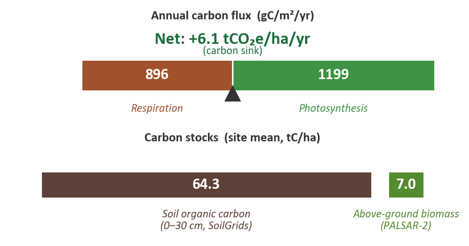
Carbon, cross-checked
Every carbon number EcoIntel produces is independently cross-checked at every parcel polygon against 14 authoritative public reference datasets: satellite products (ESA CCI Biomass, NASA GEDI L4A/L4B, Copernicus Land Cover, Hansen Global Forest Change), national inventories (UK National Forest Inventory, Italian INFC2015), peer-reviewed lookup tables (IPCC 2019 Tier-1, AGFORWARD agroforestry, UK Woodland Carbon Code, UKCEH Countryside Survey, FAO GSOCmap, ISRIC SoilGrids) and a calibrated soil-carbon model (Rothamsted Carbon Model, RothC).
Every reference produces a per-parcel verdict: green (within 1σ of the reference), amber (within 2σ), red (outside 2σ or >50% absolute deviation), or not-applicable where the reference structurally doesn't apply (e.g. GEDI on UK sites above the orbit envelope, NFI on agroforestry parcels). Site-level verdicts roll up from parcel verdicts.
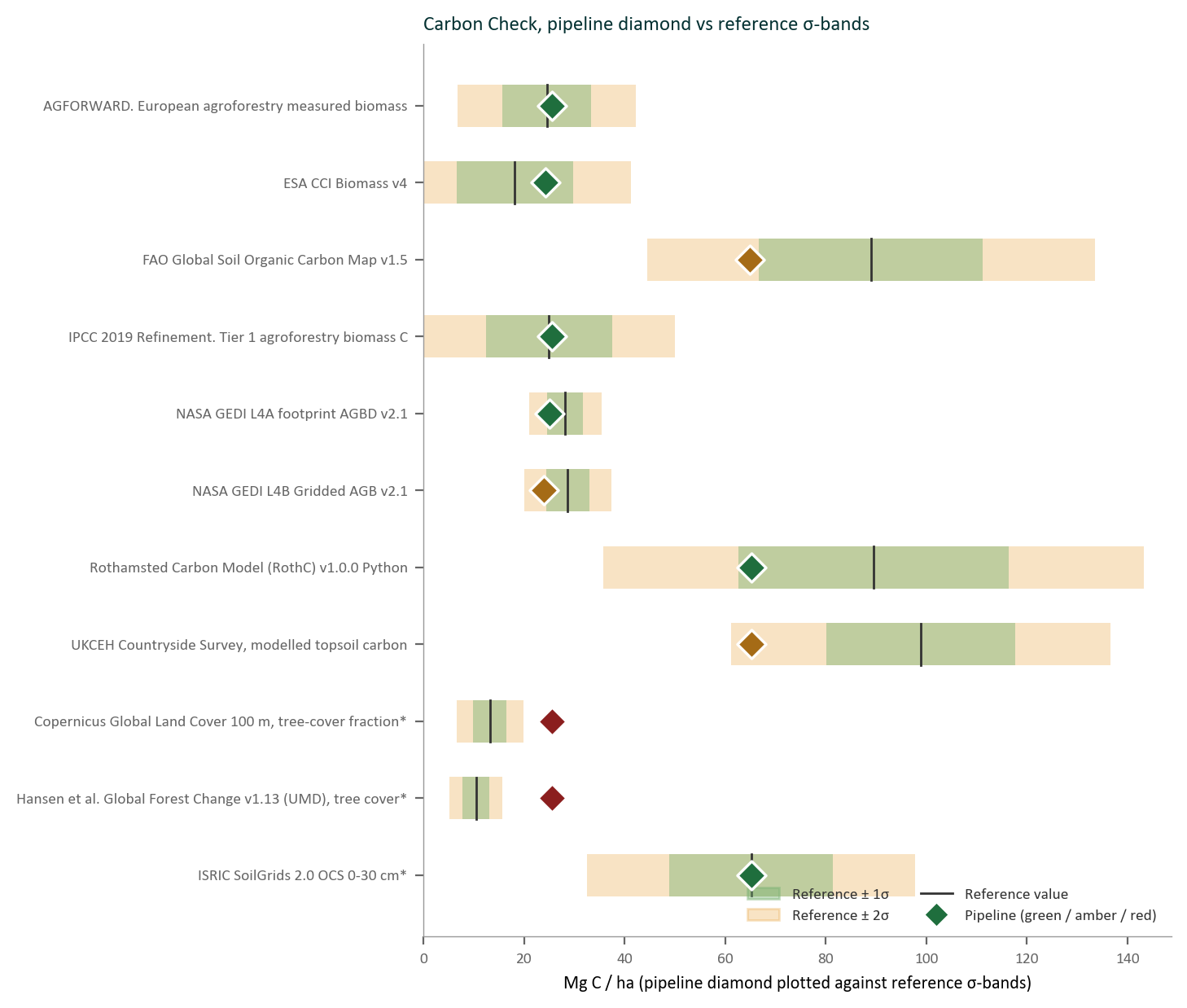
The result is the Authoritative Carbon Corroboration chapter within the Corporate edition of the master Land Health Report, quoting pipeline values, reference values, σ bands, sample sizes, and a candidate explanation for every disagreement, with full citations. Designed to be defensibly readable by an AGROMIX/CAP-style assessor or an ESRS E4 reviewer. No reference is hidden if it disagrees; every disagreement is explained.
30-year forward projection
For every productive parcel, EcoIntel projects carbon trajectory 30 years out, using the UK Woodland Carbon Code v3.0 species × yield-class × age tables for forest-track parcels and IPCC 2019 Tier-1 defaults elsewhere. Reported as cumulative tCO₂/ha at 3, 5, 10 and 30 years, with a permanence-risk label (LOW / MODERATE / HIGH / CRITICAL) per parcel.
Frameworks we align with
Each of these frameworks asks you to report ecosystem condition, the functional quality of your land, and none of them defines the metric. EcoIntel's Land Health Score is built to fill that box.
- TNFD v1.0 (LEAP)Nature-related risk and opportunity disclosure: locate, evaluate, assess, prepare
- ESRS E4Biodiversity and ecosystems: material impacts, dependencies, risks and opportunities
- ESRS E1Climate change: gross emissions, removals, transition plans
- GHG Protocol (Land Sector)Land-sector greenhouse gas accounting: Scope 1 and 3
- ISO 14064-2Project-level GHG emission reductions and removal enhancements
What satellites cannot do
EcoIntel is satellite-derived. Some regulatory frameworks require on-the-ground observation that no satellite product can substitute for. We say so explicitly, and we point you at the work that needs to happen alongside the EcoIntel signal:
- UK Biodiversity Net GainStatutory BNG requires a UKHabSurv-compliant on-site survey by a qualified botanist. We do not measure BNG and will not claim to. EcoIntel provides ecological context around the survey, not in place of it.
- SBTN-FLAGReferenced in our reports as adjacent context; full SBTN-FLAG target-setting needs supply-chain data we do not collect.
- EU Taxonomy DNSHDo-No-Significant-Harm screening references our outputs but the formal taxonomy assessment is a separate workflow.
Frequently asked
Is EcoIntel an MRV platform?
No. EcoIntel is an ADP (Assessment, Diagnostics, Practical guidance), the diagnostic layer that sits beneath MRV. Where an MRV platform answers "how many verified tonnes of CO₂ can be sold from this project?", an ADP answers "how is this land actually functioning, and what should be done about it?". We complement an MRV pipeline rather than replace it, and we do not issue verified carbon credits.
Which disclosure frameworks does EcoIntel align to?
TNFD LEAP, CSRD/ESRS E4 (biodiversity) and E1 (climate), the GHG Protocol, and ISO 14064-2. One analysis feeds multiple disclosure surfaces.
Are the carbon numbers auditor-defensible?
Every carbon figure is cross-checked at every parcel against 14 authoritative public reference datasets, each producing a green / amber / red / not-applicable verdict with full citations: internal corroboration designed to hold up to an ESRS E4 reviewer. It is not formal verification under a carbon-credit standard.
How current is the data?
A weekly-resolution, weather-corrected record with history back to 2018, so disclosure rests on a measured time series rather than a year-old snapshot.
Is satellite-based land-health measurement accurate enough to rely on?
It depends what you ask of it. Independent studies have reported that static satellite soil-carbon estimates can carry very wide uncertainty (as much as ±150%) and that detecting short-term carbon trends from satellite alone is unreliable. That is precisely why EcoIntel is an ADP, not an MRV: it diagnoses how land is functioning and where it is heading, and it never sells a tonne, so it never needs credit-grade precision. For a verified credit you still need an MRV platform; EcoIntel is the diagnostic layer beneath it.
How does EcoIntel handle that uncertainty?
Four ways. Weather-corrected scoring separates the management signal from rainfall noise. The Rothamsted Carbon Model (RothC) supplies the soil-carbon dynamics that static satellite estimates miss. Every carbon figure is cross-checked at each parcel against 14 authoritative public reference datasets, each returning a green, amber or red verdict: falsifiable corroboration, not assertion. And every figure carries a confidence label. The result is diagnostic-grade evidence you can act on and defend, explicitly not a verified carbon credit.
Ready to scope it for your portfolio?
Tell us about your portfolio, your reporting and disclosure calendar, and the frameworks you need to align with. We'll come back with a scoped Corporate disclosure plan.