Deep Knowledge
Carbon cross-checks: how 14 datasets keep us honest
A single carbon number is a hypothesis. EcoIntel cross-checks every parcel's pipeline estimate against fourteen authoritative public reference datasets and publishes the disagreements. Here is what the references are, why each is in the panel, and what the whole arrangement is for.
A single carbon number is a hypothesis. It might be right; it might not. Until you put it next to other ways of measuring the same thing, you cannot say.
This is true of any environmental measurement. Soil carbon estimated from a spectral satellite product is one hypothesis. Soil carbon estimated from a lookup table for that land cover and climate zone is another hypothesis. Soil carbon estimated from a calibrated process model run with parcel-specific inputs is a third hypothesis. They will not perfectly agree. They might disagree by a lot. The disagreements are where the interesting information lives.
EcoIntel’s Authoritative Carbon Corroboration, delivered as a section within the Corporate edition of the master Land Health Report, is built around this idea: every carbon number we produce is independently cross-checked at every parcel polygon against fourteen authoritative public reference datasets. We do not pick one source and proceed. We do not hide the disagreements. We report all of it.
This piece explains what those fourteen datasets are, why each is in the cross-check, what a “verdict” means, and what the whole arrangement is for.
The cross-check, in summary
For above-ground biomass (AGB) and soil organic carbon (SOC), EcoIntel produces a pipeline estimate per parcel, derived from satellite imagery, terrain, climate and management context. That pipeline estimate is then compared to each of the fourteen reference datasets at the same parcel polygon.
For each (parcel × reference) pair, we emit one of four verdicts:
- Green: pipeline estimate is within 1σ of the reference. Strong agreement.
- Amber: within 2σ. Reasonable agreement.
- Red: outside 2σ, or more than 50% absolute deviation. Disagreement.
- Not applicable: the reference structurally doesn’t apply to this site (e.g. NASA GEDI L4A on a UK site above the orbit envelope; the UK National Forest Inventory on an agroforestry parcel).
Site-level verdicts roll up from the parcel-level verdicts. The whole package is delivered as the Authoritative Carbon Corroboration chapter within the Corporate edition of the master Land Health Report, with σ bands, sample sizes, and a candidate explanation for every disagreement.
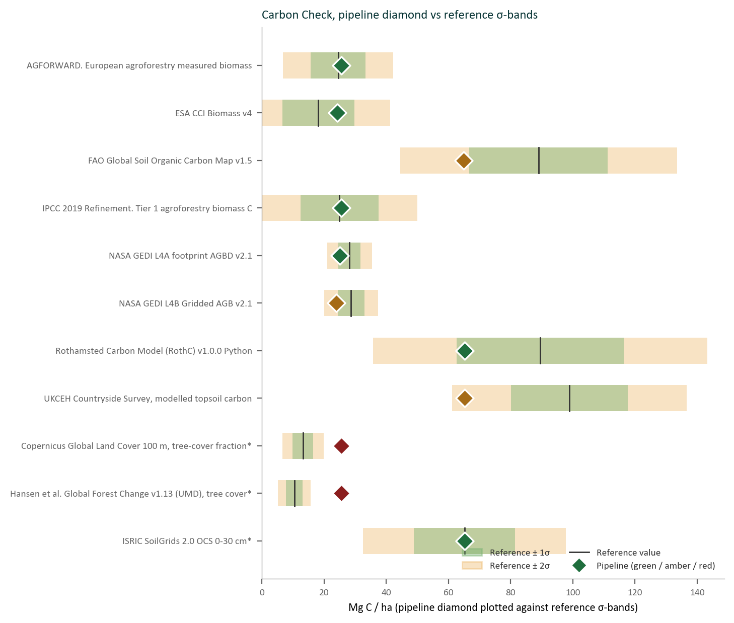
Per-reference σ-band verdicts for Wilder Wood Farm. Each reference contributes one bar showing where the EcoIntel pipeline value sits relative to that reference’s mean ± σ envelope. Green is within 1σ, amber within 2σ, red outside 2σ. The figure is the heart of the Authoritative Carbon Corroboration chapter and is the structure you can run independently against any reference yourself.
No reference is hidden because it disagreed.
The fourteen, named
The fourteen split into three families.
Spatial references: sample directly from public Earth-observation assets at native resolution
- ESA CCI Biomass v4: global 100-metre above-ground biomass map, ESA-funded, peer-reviewed methodology. Wide latitudinal coverage, including high latitudes.
- NASA GEDI L4B Gridded AGB v2.1: global 1-kilometre gridded AGB derived from lidar. NASA’s flagship spaceborne lidar product.
- NASA GEDI L4A Footprint AGBD v2.1: 25-metre sparse-pixel lidar footprints from the same mission. Coverage limited to ±51.6° latitude, the GEDI orbit envelope. UK and southern Europe are within coverage; sites further north are not.
- ISRIC SoilGrids 2.0 OCS 0–30 cm: global 250-metre soil organic carbon stock to 30 cm depth. The reference SOC product for most global analyses.
- FAO Global Soil Organic Carbon Map v1.5: global 1-kilometre SOC stock, independent of SoilGrids, built bottom-up from national soil databases.
- Copernicus Global Land Cover 100 m tree-cover fraction: Sentinel-derived fractional tree cover, used as a cross-check on woody-biomass estimates.
- Hansen Global Forest Change v1.13: UMD-produced 30-metre baseline tree cover and annual change. The official source for forest-loss disclosure in TNFD and ESRS reporting.
Lookup references: classify each parcel against verbatim values from peer-reviewed and published tables
- UK National Forest Inventory carbon-in-live-woodland: Forestry Commission inventory, species × yield class. The UK’s legal-reference forest-carbon inventory cited in its UNFCCC NIR submissions.
- UK Woodland Carbon Code v3.0: species × yield-class × age × spacing × management lookup. Used for sites running or contemplating WCC-eligible new-woodland projects, and drives EcoIntel’s 30-year forward projection on forest-track parcels.
- UKCEH Countryside Survey: modelled topsoil carbon by LCM2007 land-cover class. UK-specific independent SOC reference.
- INFC2015 Italian National Forest Inventory: Italy’s forest carbon inventory by NUTS-2 region × forest category. The Italian counterpart to the UK NFI.
- IPCC 2019 Refinement Tier-1 defaults: biomass and SOC per climate zone × land use, from IPCC Volume 4, Chapters 2 / 4 / 5 / 6. The international fallback when no region-specific data is better.
- IPCC 2019 Refinement Tier-1 agroforestry biomass: per climate zone × agroforestry system.
- AGFORWARD European agroforestry measured biomass: per (climate × system × density), from the EU AGFORWARD project’s empirical agroforestry inventory.
Model reference: re-run a published model with parcel-specific inputs and compare model output to the pipeline
- Rothamsted Carbon Model (RothC) v1.0.0: equilibrium SOC under current management, parameterised per parcel from monthly TerraClimate, SoilGrids clay fraction, and the parcel’s land-use regime. RothC is the workhorse soil-carbon model in UK agronomic science, used in both research and policy contexts.
(That is technically fifteen: fourteen are the cross-check core, and RothC is the model reference. Counting conventions vary; the Authoritative Carbon Corroboration chapter names them all.)
Why this many
Three reasons.
Different references are right about different things. ESA CCI Biomass is excellent at moderate-resolution global coverage but loses precision at field scale. GEDI lidar is exquisitely accurate where the satellite footprint lands but is sparse and latitude-limited. National inventories are definitive within their jurisdiction but don’t apply outside it. IPCC Tier-1 defaults are coarse by design: they are sanity bands, not point estimates. RothC is a process model that captures dynamics no observational dataset captures. Each is the right tool for some part of the problem; none is the right tool for the whole problem. Cross-checking against all of them is how you get a fair picture.
Single-source numbers are unfalsifiable. If you produce one carbon estimate and call it the answer, there is no way for a reader to test whether you got it right. Cross-checks against independent references, especially references the reader can fetch and verify themselves, turn the estimate into a falsifiable claim. The reader can check whether the disagreement we report is actually there.
Disagreements teach you something. When the pipeline disagrees with one reference but agrees with the other thirteen, you learn that this reference doesn’t apply well to this site. When it disagrees with several, you learn that the site is unusual, and the candidate cause for the disagreement (which the report names) points at what is unusual about it. The disagreements are often where the real ecology lives.
What a “verdict” means, and what it does not mean
A green verdict does not mean the pipeline estimate is verified-correct. It means the pipeline and that specific reference agree, within their joint uncertainty. The number might still be wrong in a way both methods share.
A red verdict does not mean the pipeline is wrong. It might mean the reference is poorly applicable to this site. It might mean the reference is itself coarse. It might mean both estimates are within their own confidence intervals but those intervals don’t overlap. The Authoritative Carbon Corroboration explains the most likely cause in plain English.
A not-applicable verdict means the reference structurally doesn’t apply here: GEDI doesn’t see north of 51.6° latitude; the UK NFI doesn’t cover agroforestry; the UK Woodland Carbon Code applies only to WCC-eligible new-woodland projects. We report these explicitly rather than pretending the reference said something it didn’t.
The verdict matrix (every (parcel × reference) pair, with its σ band, sample size, and candidate cause) is the heart of the report. It is designed to be read by a sceptical reader. We expect questions; we have tried to answer them in advance.
What this is not
This is not formal MRV verification.
A green verdict does not produce a carbon credit. An amber verdict does not produce a half-credit. The Authoritative Carbon Corroboration is internal corroboration (it supports better carbon management and is designed to be auditor-defensible as such), but it is not the output of a registered methodology under VCS, Gold Standard, Plan Vivo or any equivalent. Credits come from MRV processes, not from us. We are explicit about this in our Terms, in our Disclaimer, and in the report itself.
What the Authoritative Carbon Corroboration is, instead, is the kind of chapter that lets a reader trust the underlying numbers enough to act on them: to make management decisions, to write a CSRD/ESRS E4 disclosure, to scope a regulatory submission, to enter or exit a piece of land at a defensible valuation. The credibility comes from the multi-reference cross-check, the published σ bands, and the fact that we publish disagreements rather than hide them.
The 30-year forward projection
The cross-check tells you where the carbon is now and how confident we are about it.
For every productive parcel, EcoIntel also projects forward 30 years, using:
- UK Woodland Carbon Code v3.0 species × yield-class × age lookups for forest-track parcels
- IPCC 2019 Tier-1 defaults elsewhere
The projection reports cumulative tCO₂/ha at 3, 5, 10 and 30 years. Each projection carries a permanence-risk label (LOW, MODERATE, HIGH or CRITICAL) that reflects fire risk, drought-mortality risk, pest and disease risk (e.g. bark beetle on conifer plantations), management-change risk, and structural risk.
A projection without permanence-risk is misleading. We do not produce projections without it.
Why the report exists
Because the question “how much carbon is here, and how durable is it?” is too important and too fraught to answer with one number from one source.
Because the audiences we serve (ESG teams writing CSRD/ESRS E4 disclosures, lenders pricing property risk, advisors briefing clients, regulators reviewing claims, buyers considering nature-positive supply chains) all need defensibility, not just numbers.
Because if our number disagrees with a reference, the reader deserves to see the disagreement, not have it papered over.
And because we are a diagnostic platform, not an MRV platform. The Authoritative Carbon Corroboration is the kind of chapter that fills the diagnostic-platform niche: rigorous enough to act on, transparent enough to defend, and explicitly not a substitute for the formal-verification work that produces tradable credits. It is the work that comes before MRV, or alongside it. It is the work that lets the management decisions that produce the carbon be the right ones in the first place.
Related glossary entries
- ADP, Assessment, Diagnostics, Practical guidance: the diagnostic layer beneath MRV
- MRV Platform: the formal-verification category this corroboration is explicitly not
- Permanence Risk: the durability label on the 30-year forward carbon trajectory
- Confidence Label: how the σ-band verdicts express agreement with each reference dataset