
Metric · Glossary
Brittleness Score
Also: brittleness, brittleness rating
Definition
A 1–10 reading of how unevenly moisture is distributed through the year. Calibrates expectations: brittle land needs longer rests and recovers more slowly.
The Brittleness Score (1–10) is a context variable that calibrates what is possible, and how fast, for any given piece of land. It is not something management can change. It is a characteristic of the place, inherited from the climate.
The concept, in one paragraph
Brittleness describes how an environment responds to rest. In non-brittle environments (score 1–3), resting land recovers naturally through biological decomposition: fungi, soil fauna, mycorrhizal networks do the heavy lifting and the cover knits back together on its own. In brittle environments (score 7–10), rest alone is not enough: dead plant material oxidises and degrades on the stem rather than rotting back into the soil, the land needs periodic disturbance (such as grazing) to maintain health. Semi-brittle environments (4–6) sit in between.
Understanding brittleness is essential for choosing the right management tools, because the same low Land Health Score demands very different responses depending on where a site sits on this continuum.
The five brittleness classes, in full
The table below sets out the five classes EcoIntel uses, cut at 2, 4, 6 and 8. Those cuts are not chosen: they are the scores the mapping curve produces at its own breakpoints, so a class boundary never falls in the middle of a segment. Each class has a characteristic rainfall pattern, a characteristic rate of decomposition in the field, and a characteristic set of management risks. The continuum runs from Atlantic Ireland to North African desert.
| Class | Definition | Field validation | Management implication |
|---|---|---|---|
| 1–2 Very Non-Brittle |
Even rainfall, year-round growth, humid decomposition. | Dung & litter disappear in weeks; minimal bare soil. | Main risk = overgrazing / compaction. Focus on rest, diversity, avoiding disturbance. |
| 2–4 Non-Brittle |
Rainfall well spread, short dry season. | Dung / litter break down within 1–2 months. | Root-cause issues tend to be nutrient leaks and compaction, not water stress. |
| 4–6 Semi-Brittle |
Rainfall patchy, longer dry spells. | Dung / litter persist 2–6 months; some bare soil. | Both overgrazing and over-rest are possible; effective rainfall begins to matter. |
| 6–8 Brittle |
Long dry season; rainfall arrives in bursts. | Dung / litter persist >6 months; large patches of bare soil. | Water and mineral cycles fragile; animal impact required to restore cover and litter. |
| 8–10 Very Brittle |
Rainfall erratic; ecosystem inactive for long periods. | Dung / litter persist >1 year; moribund material accumulates; biological crusts and persistent bare ground are common at the upper end. | Over-rest is the major problem; trampling and littering essential to kick-start processes. At the upper end, water design (keyline, catchments, ponds) becomes essential. |
There is no sixth class. Earlier versions of this page listed a “Hyper-Brittle” class at 10; the curve never produced one, and the desert end of the range is the top of Very Brittle.
Reference ecoregions on the brittleness curve
Brittleness is computed from the coefficient of variation of monthly rainfall, a measure of how unevenly precipitation is distributed across the year. This replaces the subjective estimation that has been standard practice since Savory introduced the concept.
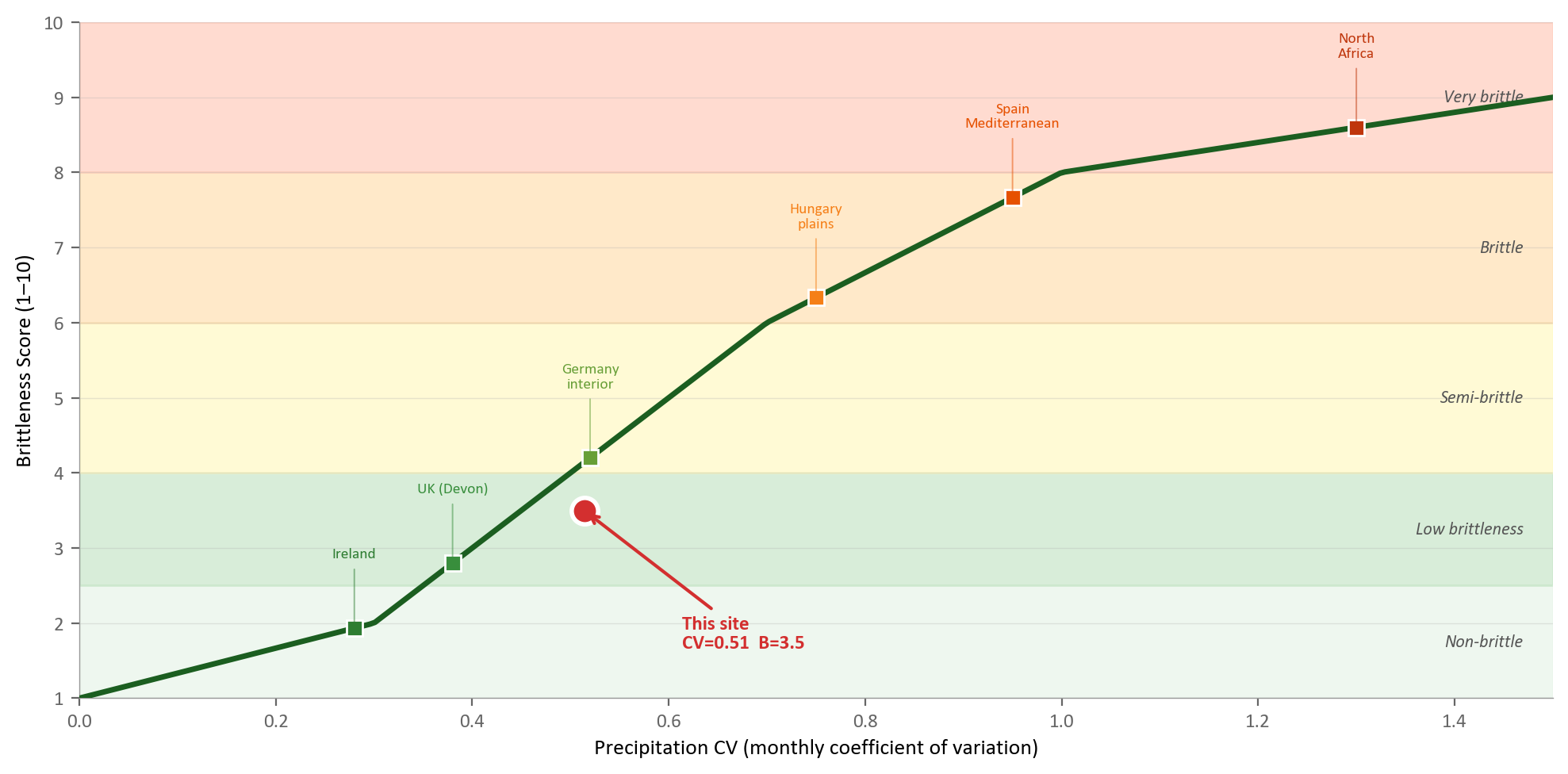
The piecewise mapping from rainfall coefficient of variation (X-axis) to Brittleness Score (Y-axis), with reference dots from European and North African landscapes. The red dot is Wilder Wood Farm at CV 0.51, B 3.4. It sits below the curve because the plotted value is the final blended score, while the curve itself shows the rainfall-variability term before the water balance is blended in.
The reference dots on the curve are values of the mapping curve itself, before the water-balance term described below is blended in. They illustrate the full continuum:
- Ireland, Brittleness ~1.9 (Very Non-Brittle). Rainfall distributed across virtually every month, dung disappears in weeks, year-round biological decomposition. Rest produces recovery reliably. The principal management risk is over-stocking.
- UK Devon, Brittleness ~2.8 (Non-Brittle). Atlantic temperate, occasional short dry summers, rainfall well-spread. Rest works; the main issues are nutrient leaks and compaction rather than water stress. (Wilder Wood Farm sits just above this point.)
- Germany interior, Brittleness ~4.2 (Semi-Brittle). Continental temperate, drier summers, intermediate behaviour. Both over-grazing and over-rest can degrade the system; effective rainfall begins to dominate.
- Hungary plains, Brittleness ~6.3 (Brittle). Pannonian basin, hot dry summers, long dormancy. Dung and litter persist months on the surface; rest alone produces moribund material. Animal impact in the right windows becomes essential.
- Spain Mediterranean, Brittleness ~7.7 (Brittle). Hot dry summers, rainfall in bursts, long inactive periods. Over-rest is the dominant failure mode; the land needs trampling and littering to restart biology.
- North Africa, Brittleness ~8.6 (Very Brittle). Desert margins, extremely irregular rainfall, persistent bare ground. Water design (keyline, micro-catchments, ponds) becomes essential alongside intensive biological re-boot.
The curve is shallow at the wet end, steepest through the middle, and shallow again at the dry end. That is deliberate: between Ireland and Devon a large difference in rainfall variability moves brittleness by about a point, because both are places where biology keeps working all year. Through the middle of the range the same difference in variability moves it twice as far, because that is where a dry season starts and stops being long enough to shut decomposition down. Past a coefficient of variation of 1 the land is already inactive for most of the year and further variability adds little.
How EcoIntel computes it
EcoIntel computes brittleness from reanalysis climate data. Precipitation CV (coefficient of variation) measures month-to-month rainfall variability across all assessment years. A low CV means rainfall is evenly distributed; a high CV means it arrives in bursts separated by dry periods.
The precipitation CV is converted to a raw brittleness score using the piecewise mapping above, then blended with a water-balance term. The final score is 70% the precipitation-derived value and 30% the water balance.
That second term is there because the CV cannot do the whole job. Reorder the twelve monthly totals and the CV is unchanged; brittleness is not. Rain that falls while plants are growing and the same rain falling while they are dormant score identically on CV and produce completely different land. So the second term measures the climatic water deficit ratio: the share of the year’s evaporative demand that rainfall and stored soil water cannot meet, taken from the TerraClimate record for the property itself. It only accumulates in months where demand outruns supply, so it carries the timing and the severity the CV misses. Those are the two remaining things the original definition rests on, humidity distribution through the year and biological decay rate.
The brittleness score and precipitation CV are therefore related but distinct measures. The CV is a pure statistical measure of rainfall variability. The brittleness score incorporates the CV but also accounts for the water balance: a CV of 0.5 in Atlantic Britain, where a summer shortfall is met from water already in the soil, has different ecological implications than the same CV in the Mediterranean, where the shortfall runs for months. The score reflects the ecological meaning of the variability, not just the variability itself.
Before August 2026 the second term was a fixed number per environmental zone, set by hand. It is now computed for the property from the same kind of climate record as the first term. A zone-level table survives as a fallback where the water-balance record does not reach, and its values are that same calculation applied to the zone.
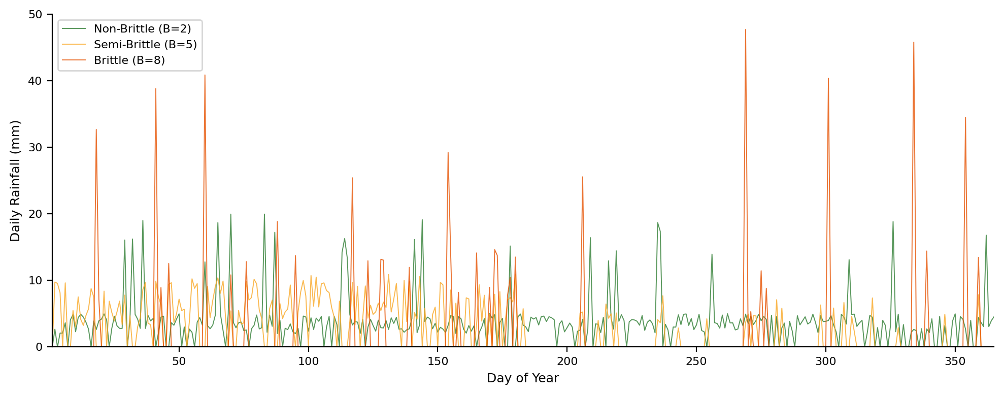
For general illustration, this chart shows how daily rainfall patterns differ across brittleness levels. Non-brittle climates (green) have consistent small rainfall events throughout the year. Semi-brittle climates (gold) show distinct wet and dry seasons. Brittle climates (orange) have long dry periods punctuated by intense downpours. The ecological consequences cascade from there: where rain is consistent, biology decomposes litter quickly; where it is bursty, litter accumulates and management has to do biology’s job.
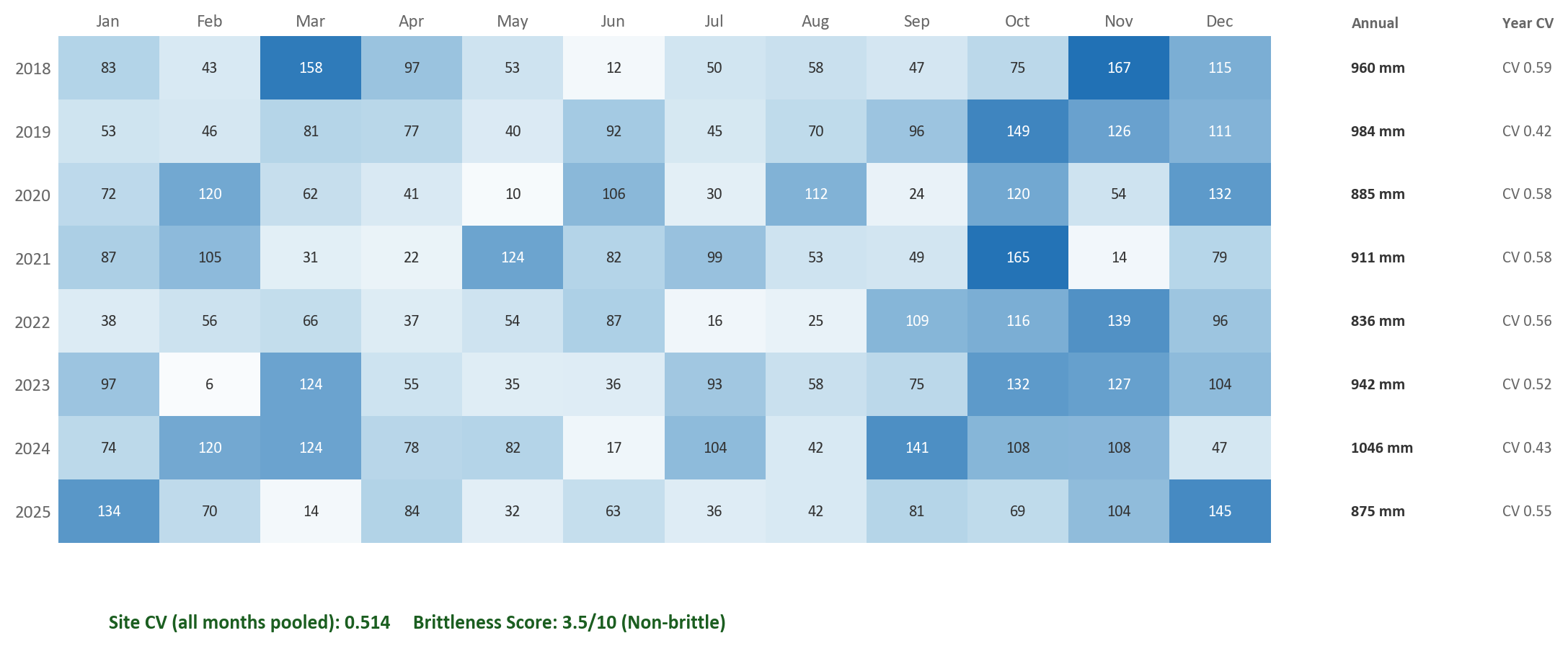
The underlying rainfall data for Wilder Wood Farm. Each cell is one month coloured by precipitation volume; the right-hand column shows the annual coefficient of variation that feeds the brittleness calculation.
For each property, EcoIntel pulls the multi-year ERA5-Land precipitation record at that location, computes the coefficient of variation of monthly rainfall (pooled across all assessment years), maps the result onto the piecewise curve, and blends it with the water-balance term. The output is one numeric Brittleness Score per site, recorded against the assessment together with the CV, the water-balance term and the number of months used, for traceability.
Brittleness is not an opinion. It is a number derived from observed climate. And because it is derived from a multi-year record, it changes only with genuine climate shift, not with last week’s weather.
Mapping the CV bands
The piecewise mapping in compact form, for the technically inclined:
| Precipitation CV | Brittleness | Category | Characteristics |
|---|---|---|---|
| < 0.30 | 1.0–2.0 | Very non-brittle | Reliable moisture, biological decay dominant |
| 0.30–0.50 | 2.0–4.0 | Non-brittle | Reliable moisture, short dry season |
| 0.50–0.70 | 4.0–6.0 | Semi-brittle | Seasonal moisture, mixed decay processes |
| 0.70–1.00 | 6.0–8.0 | Brittle | Unreliable moisture, physical weathering dominant |
| ≥ 1.00 | 8.0–10.0 | Very brittle | Arid / semi-arid, extreme unpredictability |
Why brittleness reorders the management cascade
Two farms with the same Land Health Score can need very different first moves depending on their brittleness:
- A non-brittle site at Land Health Score 5 (Transitional) responds to rest plus species enrichment. Rest gives the existing biology time to do its work; diversity unlocks the next ceiling. Buying seed is the last resort.
- A brittle site at the same Land Health Score 5 responds to planned high-density grazing pulses plus water design. Rest alone allows litter to stand un-decomposed, capping the surface. Animal impact in narrow windows trampling that litter is the lever; building infiltration and water capture is the foundation everything else needs.
EcoIntel uses brittleness as a context variable behind every diagnosis. Recommendations adjust to it. Rest periods lengthen or shorten. Intervention timing shifts. The BROWN → BLUE → GREEN → BLACK cascade reorders. Calibrating expectations to brittleness prevents both over-optimism (in brittle systems) and unfair disappointment (in non-brittle ones).