Demonstration property · WLD
Wilder Wood Farm
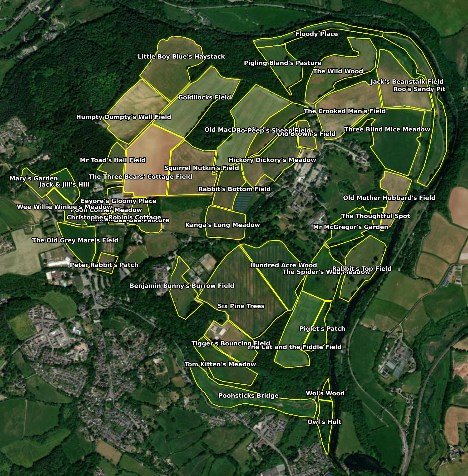
Davonia (fictional county), United Kingdom. 175.2 hectares across 44 parcels.
- Ecoregion
- Atlantic Central
- Brittleness
- 3.4 / 10
- Regime
- Mixed grassland + agroforestry + wood-pasture
- Area
- 175.2 ha
- Assessment history
- 2018–present
Wilder Wood Farm is EcoIntel’s public demonstration property. Anyone can sign up to the free demo plan and open the full report suite for this site: same scoring engine, same prose, same depth of analysis as a paying subscriber sees for their own land. It is the only property whose data appears publicly on this site; all other EcoIntel sites are GDPR-protected client sites and never surface in public-facing content.
Why Wilder Wood Farm
Wilder Wood Farm is mixed, multi-decadal, and honestly variable. It carries the kinds of complications real working land carries: wet valley toes that throttle photosynthesis, alley-cropping rotations that cycle through harvest pulses, wood-pasture parcels recovering from canopy disturbance, a five-field grassland tail in the Degraded band, and a north-facing reference paddock (Peter Rabbit’s Patch, Land Health Score 7) that demonstrates what the rest of the platform could become.
It is also varied enough to demonstrate ecoregion-and-regime-aware scoring. The thirty-eight grassland parcels are scored against a grassland-ensemble reference; the four tree-integrated parcels (Owl’s Holt, Hundred Acre Wood, Six Pine Trees, Wol’s Wood) are scored against forest-track references. There is no single site-wide Land Health Score for a property of this composition, and the report does not invent one: the two regimes’ stories are told side by side. Few demo properties allow that two-track diagnosis to be shown honestly.
Key findings (2025 assessment)
- Land Health Score 5 (Transitional, ~10) site-wide on the grassland ensemble; forest-track parcels aggregate to Score 5 (Transitional, 58%) over 21.1 ha.
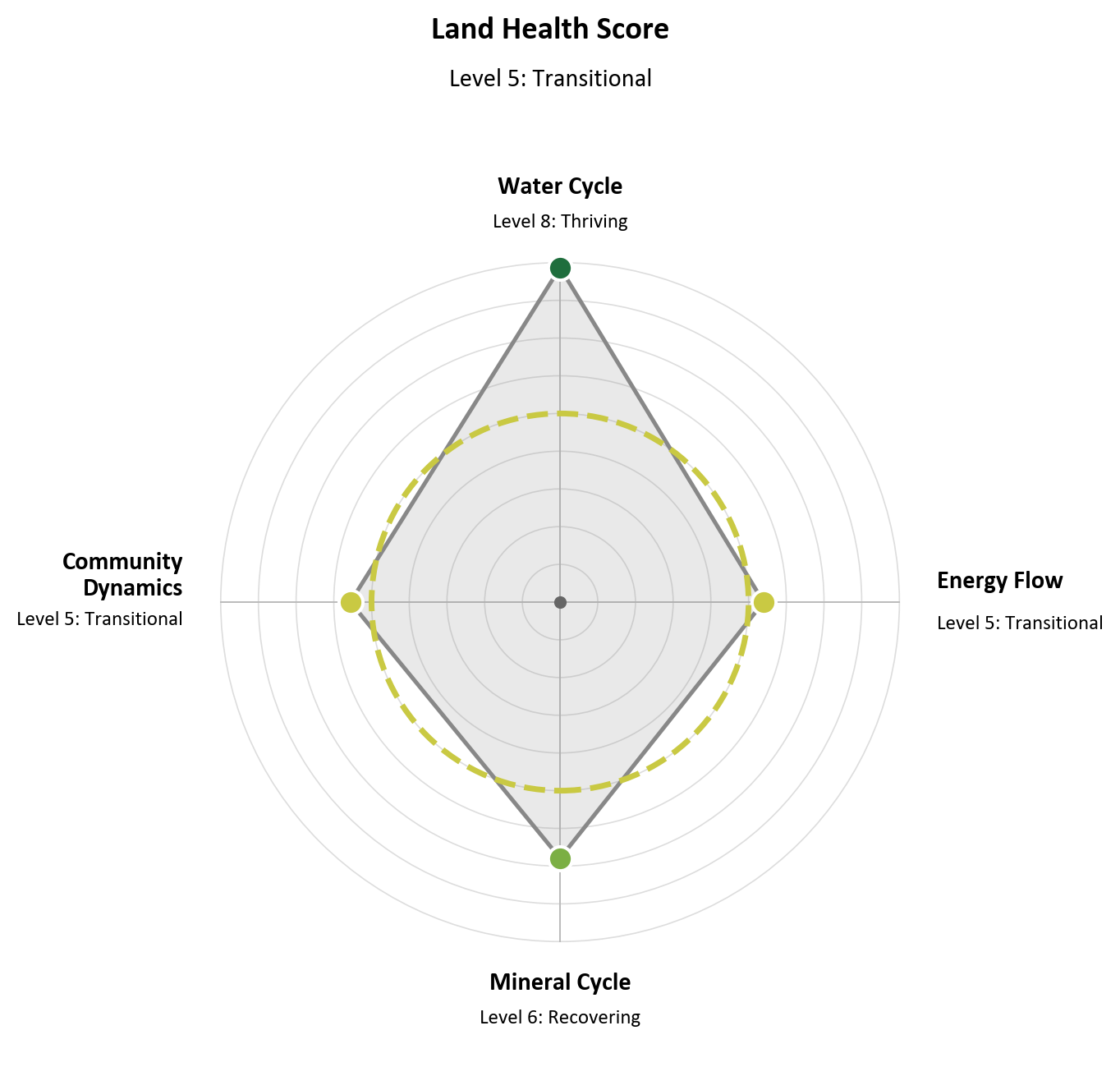
- Limiting process: Community Dynamics at 56% across 36 of the 38 grassland parcels, a productive-but-narrow signature. Rainfall is infiltrating, mineral cycling is solid, energy capture is healthy, but the species pool has thinned under selective grazing pressure.
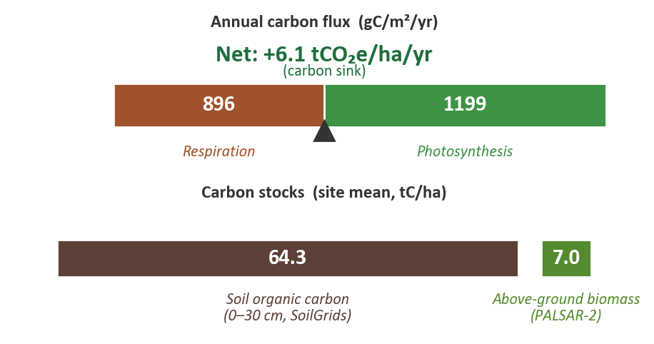
- Carbon balance: net +6.1 tCO₂e/ha/yr, a strong working sink for a temperate Atlantic estate. 1,199 g C/m²/yr photosynthesis against 896 respired, a 34% margin in favour of capture. ~1,069 tCO₂e captured across the 175 ha in 2025.
- Peter Rabbit’s Patch (Land Health Score 7) is the in-property reference for what the rest of the grassland can become, a north-facing valley paddock returning 91% water cycling, 78% energy capture, 82% mineral cycling, 68% community diversity.
- Five-field grassland tail (Three Blind Mice Meadow, Goldilocks Field, Old MacDonald’s Farmyard, The Cat and the Fiddle, The Old Grey Mare’s Field) carries most of the downside risk and is the priority intervention set.
- Owl’s Holt forest-track parcel has stepped down from Score 5 in 2018 to Score 3 in 2025 through a sequence of biomass-drop signals culminating in a September 2025 canopy event. Needs ground inspection.
The report suite for Wilder Wood Farm
Because Wilder Wood Farm is the demonstration property, it ships in a DEMO bundle that includes both the Standard (5 reports) and Corporate (6 reports) packages side by side, so a prospect can compare what each tier delivers without paying for either. Standard subscribers see five PDFs; Corporate subscribers see six (with the Authoritative Carbon Corroboration chapter and a Sustainability & Disclosure chapter extending the master report).
How the property scores today
Two of the headline visualisations from the 2025 assessment. The Ecosystem Process Kite shows the four-process diamond; the Carbon Balance shows the property as a working sink.
Want to see the reports for this property?
Sign up free to open the complete Wilder Wood Farm report suite: all six reports across the Standard and Corporate packages, side by side.